
George Sheehan wrote, in his 1978 book Running and Being, “When I get that look in my eye that’s says I’m going ‘away,’ do me a favor. Let me go.”
For most, running is a meditation, a way to escape the everyday. Lucky for Los Angeles locals, there is many a place to transcend the traffic of the city and take off, running. Here are twelve of Los Angeles’ best runs.

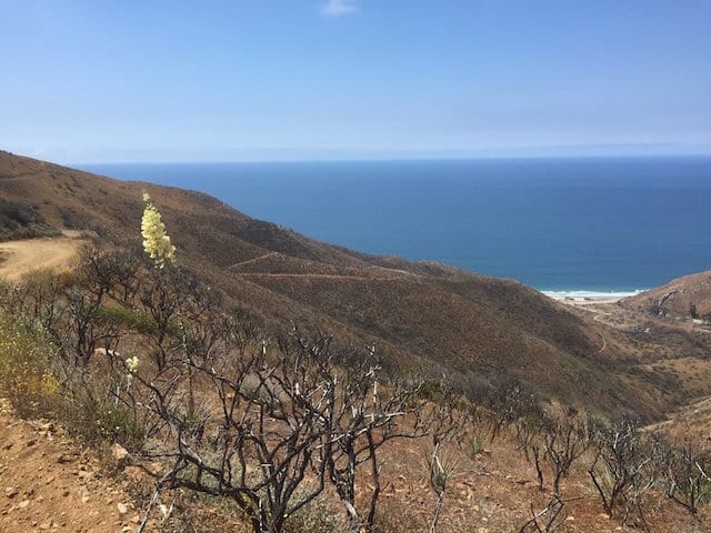
RAY MILLER BACKBONE TRAIL
Ray Miller Trail is located off Pacific Coast Highway in Malibu and well worth the drive out. As a friend describes it: “Ray Miller Trail is like Lord of the Rings, but the last time I was there (a year ago) it was a moonscape scorched by wildfires.” The run is 5.4 miles back and out with spectacular views of the ocean. It’s part of the much longer 67-mile Backbone Trail. The namesake of this section, Ray Miller, was nicknamed the “Guardian of the Canyon,” as described in a plaque with a bearded depiction of the man himself.
The Ray Miller Backbone Trailhead is located at Pacific Coast Highway and La Jolla Canyon in Malibu, 90265
SAN VICENTE MOUNTAIN
Westridge Trail on San Vicente Mountain is known for its 360 degree views, which add to that sense of accomplishment one feels after a run. This trail also offers the chance to experience Cold War history. At the top of the mountain, you will encounter a Nike missile center, used in the ’50s and ’60s to “detect and track hostile aircraft, and to guide the anti-aircraft missiles that would be launched from nearby Sepulveda Basin to their targets,” according to the Santa Monica Mountains Conservancy. There are various points of entry for this trail, but if you want to cover the most distance enter on Westridge Road, which is off Mandeville Canyon in Brentwood. The trailhead is located at the very end of Westridge Road. There is limited parking, but it tends not to get too crowded. The trail is 7.4 miles round trip.
The Westridge trailhead is located at the end of Westridge Road in Los Angeles. 90049
**There used to be an easement that offered a slight variation of the trail on Old Ranch Road, a private road neighboring Mandeville Canyon, but it appears as if that entrance is now closed to the public.

MARVIN BRAUDE BIKE TRAIL
Also known as The Strand, this path is 22 miles long and the terrain is flat the entire way. It gets a little congested at times with both pedestrians and bikes. The path starts at Will Rogers State Beach and travels through Santa Monica, the Venice Beach Boardwalk, alongside LAX at Dockweiler State Beach, and through Manhattan Beach before ending at Torrance State Beach. There are many atmospheric changes to take in as you travel southbound through each city. At one point, you run through a spectacular tunnel underneath the Santa Monica Pier, punctured with holes where the sunlight beams through. Since it’s mostly adjacent to the beach, there are plenty of bathrooms along the way, and even places to stop for a quick refreshment. The path was officially named after Marvin Braude in 2006, a Los Angeles City Councilman partially responsible for banning smoking in restaurants.
Will Rogers State Beach is located at 17000 Pacific Coast Highway in Pacific Palisades, 90272

RUNYON CANYON
Despair echoed through West Hollywood as Runyon Canyon closed for most of the summer, but it isback and better than ever. Known as a trendy ‘it’ scene, there is a reason actors and other health enthusiasts flock to this mountain: it really is a great hike, and, if you’re fit enough, a great run. Although it is not so as much of an escape as it is a see-and-be-seen atmosphere, the mountain has its advantages—not the least of which being that it’s centrally located in Los Angeles. One entrance is in West Hollywood at Fuller Avenue and the other, at the top, is located on Mulholland Drive. Once on the mountain, there are various routes to take depending on your fitness level.
Runyon Canyon is located at N. Fuller Avenue in Los Angeles. The north entrance is located at 7317 Mulholland Drive in Los Angeles

UCLA DRAKE STADIUM TRACK
One of the best tracks in Los Angeles is at UCLA’s Drake Stadium. Located in Westwood on the school’s campus, the track is a standard 400 meter loop with nine lanes. Many people also use the stadium seating to incorporate stairs into their workout. They are regularly open to the public, but be sure to check their track and field schedule to make sure there isn’t an event that conflicts with their regular hours.
UCLA Drake Stadium Track is located at 340 Charles E. Young Drive North in Westwood. (310) 825-4546
BRENTWOOD TO SANTA MONICA IN THREE PARTS:
Part One: San Vicente Boulevard
San Vicente in West L.A. is an expansive boulevard with a grassy center divide that is perfect for running, even though there is little grass remaining since the sprinklers were turned off. Start at the Brentwood Country Mart at San Vicente and 26th Street, and run west down San Vicente Boulevard. You can start further east if you want a longer run, but you’ll experience more congestion from the storefronts, rather than the calm of the suburban neighborhood that starts just west of 26th Street.
If you’re lucky, you might catch sight of Garry and Jason Clemmons—a locally famous pair of identical twin brothers who are often seen running in sync down San Vicente in matching shorts. They run 16 to 20 miles a day, six days a week. Their stop-light training is always perfectly in sync. The Clemmons Twins, whose voices echo in unison over the phone, said “We run so many miles every day, we want to be smart on our joints.” When asked how they do so, they replied, “We pray over our knees in the name of Jesus, and we trade out our sneakers.”
This section starts at San Vicente Boulevard and 26th Street in Brentwood.
Part Two: The Santa Monica Stairs
Los Angeles has many sets of outdoor stairs, but the Santa Monica Stairs are perhaps the most famous, the most crowded, and the ones with the best view. From 26th Street to 7th Street, you will have to run 1.7 miles. Take a right turn on 7th street, and a left turn on Adelaide. Here you will encounter one of the two sets of Santa Monica Stairs. These are wooden steps with a few concrete mixed in. There are approximately 160 to 170 steps, producing an overall vertical change of about 109 feet. There is a second set of stairs that are all made of concrete and are slightly longer. That entrance is on Ocean and 4th Street. The steep incline is no joke, so after tiring yourself from a few rounds of the stairs continue onto the third and final segment by running west on Adelaide to the end of the road. Turn left on Ocean Avenue.
The Santa Monica Stairs are located at 699 Adelaide Drive in Santa Monica.
Part Three: Palisades Park
Overlooking the ocean atop Pacific Coast Highway is a pedestrian path alongside Ocean Avenue. It feels completely separate from the traffic of Ocean Avenue, since the path is surrounded by tall trees and grass on both sides. The entire path is, in fact, a 26.4 acre park operated by the City of Santa Monica. The refreshing ocean breeze will cool you off, and there are plenty of benches along the way if you want to take a break and take in the view.
Palisades Park begins at the western terminus of Ocean Avenue in Santa Monica.
SILVER LAKE RESERVOIR
While the fate of the Silver Lake Reservoir remains somewhat in flux, the path around its circumference remains one of the most popular places in the city to run. The dirt path is 2.2 miles with slight hills. The only downside is you stare at the reservoir—which is currently empty—through a chain link fence, so this run doesn’t exactly rival some of the views from the others on this list, but for easy access and a more straightforward track-like run, the Silver Lake Reservoir is a great place to exercise.
The Silver Lake Reservoir is located from 1854 to 2246 Silver Lake Boulevard in Silver Lake.
GRIFFITH PARK
If you’ve already run Ray Miller Trail or Westridge Trail, you’ve run the western part of the Santa Monica Mountains. Griffith Park gives you the opportunity to explore the eastern end of the range in the nation’s largest city park with urban wilderness. There are many routes to take across this mountain so pick your preference, or just go exploring. One short but steep route takes you from Trails Cafe up to the observatory, and many of the routes offer a view of the Hollywood sign.
Griffith Park is located at 4730 Crystal Springs Drive in Los Angeles, although there are various entrances.

Rose Bowl exterior. (Photo by Robert Laberge/Getty Images)
THE ROSE BOWL
This 3.3 mile loop runs the circumference of the L.A.’s historic Rose Bowl Stadium, and the Brookside Golf Course. The loop is a little over the distance of a 5K, so many race events are held there. When there is not an event, people of all ages come to train. There are even 14 fitness stations (targeting stretching, balancing, coordination and strength building exercises) along the way to supplement your workout, as well as a public pool in case you happen to be training for a triathlon (or just want to go for a swim).
The Rose Bowl is located at 1001 Rose Bowl Drive in Pasadena.
THE SEPULVEDA BASIN
Located in Encino at the top of Woodley Park, the Sepulveda Basin offers a few looped routes, including one that crosses the L.A. River and runs around the golf courses, and one that surrounds Balboa Lake. Routes range in mileage. Depending on your path, you could encounter the iconic Sepulveda Dam, which has been featured in multiple movies (including The Fast and the Furious) and countless car commercials. If you have time after your run, cool down with a stroll through the nearbyJapanese Garden.
The Sepulveda Basin is located at 5600 Woodley Avenue in Lake Balboa.
Article courtesy of LAist.